|
Dataset ID: |
198 |
|
Name: |
Heat Vulnerability Study 2020 |
|
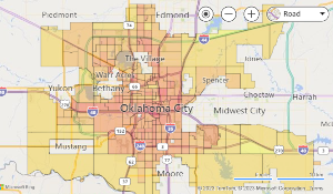
Description: |
The 2020 Heat Vulnerability Index is based on factors related to sensitivities to heat, adaptive capacity, and exposure. This Index was developed in 2022 by University of Oklahoma (OU) assistant professor of Landscape Architecture, Dr. Wenwen Cheng. The project titled “A Spatial Decision Support System for Identifying Heat Vulnerability Based on a Comprehensive Energy Budget Model and Multi-Criteria Decision Analysis in Oklahoma City, OK,” was funded by a NASA ROSES grant award to OU. |
|
Keywords: |
heat vulnerability study 2020 Heat Study Sustainability |
|
Data Updated: |
1/1/2024 6:01:00 AM |


|
Filter By Map |


|
Filter By Attribute |

|
Download |

|
|
Filter Table by Map
When this filter is applied, the displayed table contents are updated when you pan or zoom map.
For some datasets you may need to zoom the map in to see any records.
Filter Table Data
|
Field: |
|
|
Operator: |
|
|
Value: |
Download Table Data
Select Download Format:
Select Records of Interest:
* Not available on all datasets.
Preparing your file...