|
Dataset ID: |
11 |
|
Name: |
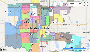
Zipcodes |
|
Description: |
Datasert showing the various postal zipcode boundaries within the greater Oklahoma City municpal boundary. It includes the post office (city) name associated with the zipcode. |
|
Keywords: |
zipcodes boundaries boundary |
|
Data Updated: |
1/1/2026 6:00:06 AM |


|
Filter By Map |


|
Filter By Attribute |

|
Download |

|
|
Filter Table by Map
When this filter is applied, the displayed table contents are updated when you pan or zoom map.
For some datasets you may need to zoom the map in to see any records.
Filter Table Data
|
Field: |
|
|
Operator: |
|
|
Value: |
Download Table Data
Select Download Format:
Select Records of Interest:
* Not available on all datasets.
Preparing your file...